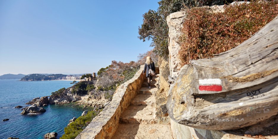
Hiking
If you love hiking, we recommend seven routes that will help you get to know our area, taking you from the most solitary coves to the oak and pine forests inland in no time.
Relevant links:
Wikiloc, GPS routes and points of interest
View and download the Hiking and Mountain Biking map
Routes:
GR 92-2 (variation of the Mediterranean trail)
This route joins the city of Lloret de Mar with the Tordera river in the Pla de Gelpí area.
The route begins in the very centre of Lloret de Mar. From there, you can discover a wide range of typical examples of Mediterranean culture: the chapel of the Virgen de las Alegrías, important sanctuaries like El Vilar and Sant Pere del Bosc and a whole array of forest trails with fields and woodland typical of the area. The experience culminates at the Tordera river, where you have the option to go back to Lloret the way you came, or join the GR92 track (Mediterranean trail) that runs along the cost, and discover all the coves and beaches that connect Blanes to Lloret de Mar.
Town: Lloret de Mar
Distance: 14 km
Approx time: 3 h 30 m
Type of route: Linear
Difficulty level: Medium
Accumulated climb: 162 m
Accumulated descent: 152 m
Trail markings: White/red
You can download the booklet with this route by clicking here
Caulès route
The Caulès trail is a route that runs between Lloret de Mar and Vidreres.
The route begins at the Maritime Museum in the centre and heads out towards the Mediterranean forests that surround the two towns. One place you have to stop is Puig de Montgrós, where you can enjoy good views of the area.
As the name suggests, the route ends at the chapel of Santa Susana de Caulès in Vidreres.
The route is very long, and you need to be well equipped.
Town: Lloret de Mar
Distance: 31 km (there and back)
Approx time: 6 h 30 m
Type of route: Semi-circular
Difficulty level: Hard
Accumulated climb: 720 m
Accumulated descent: 722 m
Trail markings: White/yellow
You can download the booklet with this route by clicking here
Lloret Beaches route
If you like the sea and nature, look no further than this is the route that runs along the entire coastline of Lloret de Mar.
The route begins at Santa Cristina Beach, crossing the whole coastline of the town, and ends at Canyelles Cove. Don’t forget that you will also discover a wide array of natural and cultural heritage, like Santa Clotilde Gardens, Monument to the Dona Marinera and the Castle of Sant Joan.
Town: Lloret de Mar
Distance: 9.4 km
Approx time: 3 h
Type of route: Linear
Difficulty level: Easy
Accumulated climb: 209 m
Accumulated descent: 199 m
Trail markings: White/red
You can download the booklet with this route by clicking here
For an alternative route in case the trail is temporarily closed, click here
Access the interactive map by clicking here
Chapels route
This is one of the riches routes in terms of modernist art combined with nature.
Among the oak and cork tree forests you will find chapels, like the Virgen de las Alegrías, monuments, like L’Àngel, and the sanctuary of Sant Pere del Bosc. The route includes a stretch of the Lloret coast and some of its beaches and coves.
Town: Lloret de Mar
Distance: 19 km
Approx time: 4 h
Type of route: Circular
Difficulty level: Easy
Accumulated climb: 291 m
Accumulated descent: 285 m
Trail markings: White/yellow
You can download the booklet with this route by clicking here
Access the interactive map by clicking here
Montbarbat route
The Iberian settlement of Montbarbat is the largest archaeological site in Lloret, measuring 5,700 m2. It is surrounded by defensive walls and towers and also boasts very good panoramic views of the coastline.
The route begins at the Maritime Museum in the centre, passes by various modernist attractions in the area, like the Chapel of Les Alegries, Sant Pere del Bosc and the cross, all in the midst of nature, and ends at the Iberian settlement.
Town: Lloret de Mar
Distance: 22.5 km (there and back)
Approx time: 5 h
Type of route: Semi-circular
Difficulty level: Hard
Accumulated climb: 403 m
Accumulated descent: 397 m
Trail markings: Green
You can download the booklet with this route by clicking here
Access the interactive map by clicking here
Old road route to Tossa
This route joins the towns of Lloret de Mar and Tossa de Mar along the typical Mediterranean coastline, filled with beaches, coves and unforgettable places to enjoy the day.
Town: Lloret de Mar
Distance: 15 km
Approx time: 3 h 30 m
Type of route: Linear
Difficulty level: Medium
Accumulated climb: 205 m
Accumulated descent: 203 m
Trail markings: White/purple
You can download the booklet with this route by clicking here
Lloret de Mar – Vidreres route, via Caulès Chapel
This route connects the two towns of Lloret de Mar and Vidreres via the Caulès Chapel.
The trail is rich in nature as it passes through the Ardenya-Cadiretes massif, a natural area home to the Caulès Chapel.
Along this route, you will also come across the Chapel of the Virgen de las Alegrías (Lloret) and Sant Iscle Castle, which is at the end of trail just outside the town of Vidreres.
Town: Lloret de Mar
Distance: 21.4 km
Approx time: 4 h 30 m
Type of route: Linear
Difficulty level: Medium
Accumulated climb: 538 m
Accumulated descent: 460 m
Trail markings: White/yellow
You can download the booklet with this route by clicking here
Puig de Castellet route
This is the shortest route in the town of Lloret de Mar.
Departing from the centre of Lloret at the Maritime Museum, you can also pass by the Roman tomb and enter the settlement through the urbanised area of Turó de Roca Grossa.
Another option is to walk through the Molí district, through Can Ballell, and climb up to Roca Grossa.
Town: Lloret de Mar
Distance: 2.7 km
Approx time: 1 h 15 min
Type of route: Linear
Difficulty level: Easy
Accumulated climb: 169 m
Accumulated descent: -m
Trail markings: White
You can download the booklet with this route by clicking here
Other activities

Sea routes
The Sea routes, or Rutes de mar in Catalan, comprise a public network of marine routes along the Costa Brava designed for sports, leisure and educational activities
Read more
Sea kayaking
If you want to reach otherwise-inaccessible coves and discover Lloret de Mar’s coastline, kayaking is the best option for you.
Read more
Snorkel
If you fancy a lighter way to discover life beneath the waves, without having to swim or dive too far
Read more
Diving
The crystal-clear waters of the Costa Brava are the perfect space for diving fans to discover our impressive marine flora and fauna.
Read more
Nordic walking
Nordic walking has grown in popularity in recent years and is an ideal way to exercise and discover Lloret de Mar.
Read more


© Lloret Turisme - Lloret Futur S.A. - Ajuntament de Lloret de Mar. Av. Alegries, 3. · 17310 Lloret de Mar · Tel. + 34 972 365 788 · central-turisme@lloret.cat
Download the results
We send you the PDF file with your results to your email in order to save or print. * When printing, select the "Background graphics" box to view the content correctly.